No products
Product successfully added to your shopping cart
There are 0 items in your cart. There is 1 item in your cart.
Maps There are 65 products.
-
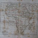
Antique map of northern regions of Africa....
Antique map of northern regions of Africa (Barbarie, Egypte, Nigritie, Guinee, Nubie, Abissini). An interesting map created by Robert de Vaugondy for the 'Atlas Universel' in 1757 and corrected by his successor Lamarche. The Atlas is one of the most important 18th-century atlases. This impression was published after the French Revolution and dated as year...
170 €Exhausted -
Antique map of shoutern regions of Africa....
Antique map of shoutern regions of Africa (Congo, Cafrerie). Robert de Vaugondy (1804). An interesting map created by Robert de Vaugondy for the 'Atlas Universel' in 1757 and corrected by his successor Lamarche. The Atlas Universel is one of the most important 18th-century atlases. This impression is dated on 1804. Plate size: 25,4x24 cm. Paper size:...
170 €Available -
Antique map of Mexico and America Central....
Antique map of Mexico and America Central (Nouvelle Espagne, Nouvelle Mexique, Isles Antilles). Robert de Vaugondy (1794). An interesting map created by Robert de Vaugondy for the 'Atlas Universel' in 1757 and corrected by his successor Lamarche.
240 €Available -
«Paraguay, Chill, Terre Maguellan par...
Grabado por E. Dussy. Revisado y corregido por Delamarche su sucesor. Giles y Didier Robert de Vaugondy, padre e hijo, fueron famosos cartógrafos del siglo XVIII, descendientes del también cartógrafo Nicolas Sanson del que heredaron gran parte de su material cartográfico. En 1760 Didier Robert de Vaugondy fue nombrado geógrafo de Luis XV. En 1757...
180 €Available -
Antique map of the First Ages of the...
Antique map of the First Ages of the World (Carte des Premiers Ages du Monde). Robert de Vaugondy.. An interesting map created by Robert de Vaugondy for the 'Atlas Universel' in 1757 and corrected by his successor Lamarche. The Atlas Universel is one of the most important 18th-century atlases.
200 €Available -
Antique map of Judea on Holy Land. Robert...
Antique map of Judea on Holy Land (Judee on Terre Sante). Robert de Vaugondy. An interesting map created by Robert de Vaugondy for the 'Atlas Universel' in 1757 and corrected by his successor Lamarche. The Atlas Universel is one of the most important 18th-century atlases. Plate size: 26x29,8 cm. Paper size: 31,8x45 cm.
180 €Available -
Frederick de Wit «Accuarantissima...
Grabado al cobre de Frederick de Wit.realizado en 1660/1680. Lleva una cartela arriba a la iquierda con el título y seis puttis y otra abajo a la derecha con cuatro puttis. Buena conservación. Medidas grabado 49x57 cms. papel 53x64,5 cms.
1 000 €Available -
F. de Wit. «Regnorum Castellae Navae,...
Interesante grabado de Castilla, Andalucia, Valencia y Murcia. En la cartela de abajo a la derecha hay cuatro puttis. Frederick de Wit nació en 1630 fue un famoso grabador en Ámsterdam. Sus mapas se hicieron muy populares por la calidad de sus grabados. Medidas: 52x60 cms.
1 000 €Available -
Charte vom Konigreich Württemberg Baden...
Engraving of Württemberg Baden edited in Augsburg by Joh Walch. Image measures 22x19 cm.
110 €Available -
Karte von dem Turkischenreiche in Europa...
Engraving of Turkey edited in Augsburg by Joh Walch. Measures 22x19 cm.
110 €Available -
Karte des Europaeischen Russland edited in...
Russian engraving edited in Augsburg by Joh Walch. Measures 22x18 cm. Written in pencil on the reverse.
110 €Available -
Karte der Mark Branderburg Pommern edited...
Engraving of Brandenburg by Joh Walch. Measures 18.7x22 cm.
100 €Available -
Charte von Italien edited Augsburg by...
Engraving from Italy or Johannes Walch. Measures 22x19 cm.
120 €Available -
The Black Sea and surrounding countries
Old engraving of the Black Sea and surroundings. Measures 19x26 cm.
70 €Available -
Charte des Preussischen States edited in...
Engraving edited in Augsburg by Johannes Walch. Measures 18.3x22.5 cm.
100 €Available -
Charte vom Koenigreich Baiern Württemberg...
Engraving edited in Augsburg by Johannes Walch. Measures 18x22.5 cm.
100 €Available -
Charte von Oesterreich bei Joh Walch 1812
Engraving edited by Joahnnes Walch in Augsburg. Measures 19x23 cm.
100 €Available -
L. Vivien «Carte de la Peninsule...
Carte de la Peninsule Hispanique ou sont compris les Royaumes dEspagne et Portugal avec divissions en provincies Medidas imagen 43ex55 cms. papel: 57x71 cms. Buena conservación. Tiene manchas de humedad en los márgenes del grabado que no le afecta.
225 €Available -
Carte de l'Espagne&de Portugal by Pieter...
Map of Spain and Portugal by Pieter Vander Aa under the pseudonym Alvarez de Comenar made in 1707 from the work Delices de l'Espagne. It comes from the work of Pieter van der Aa Delices de Espagne et Portugal, published in Leyden (Holland) 1707 is the most illustrated work on Spain published at the beginning of the eighteenth century. Image measures...
90 €Exhausted -
Military itinerary map of Spain, Alicante,...
Interesting old cartographic map of the province of Alicante. scrim map. Made in 1892. Folded measurements: 15x11 cms. Unfolded: 47.5x66 cm.
130 €Available


